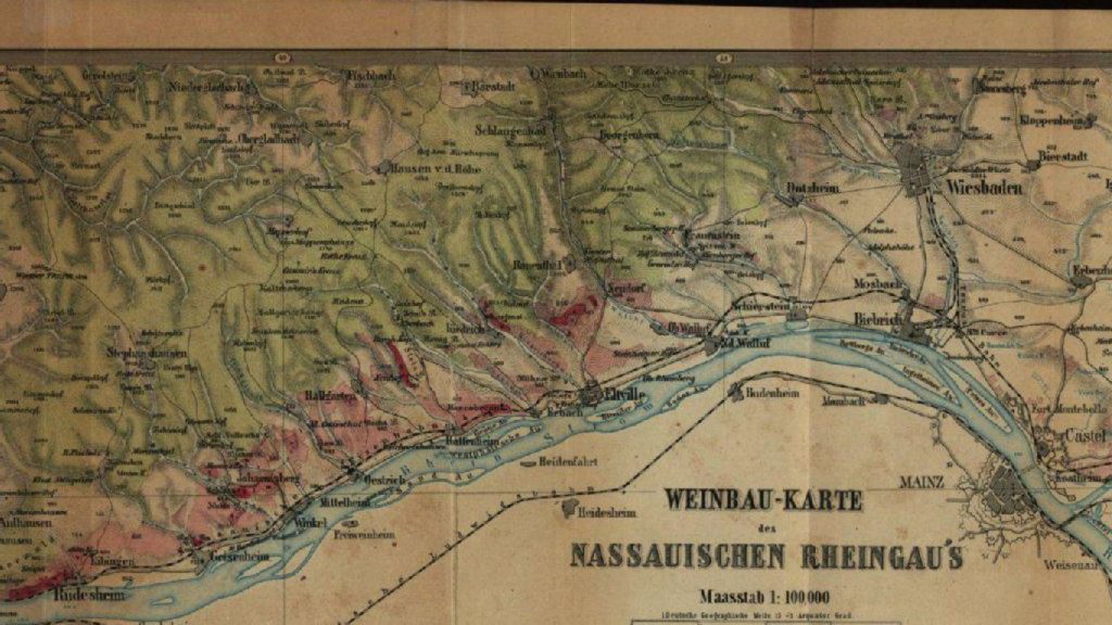
The world of wine is full of history, stories, and discoveries waiting to be uncorked. One such intriguing revelation is the “Weinbau-Karte des Nassauischen Rheingau’s,” a wine classification map created by Dr. Friedrich Wilhelm Dünkelberg, the director of the Royal Prussian Agricultural Academy in Bonn-Poppelsdorf back in 1867. This historic map offers a unique perspective on the wine regions of the Rheingau, and it was hidden away for nearly 150 years before its rediscovery. Join us as we explore the fascinating tale of this wine map and how it reshapes our understanding of the region’s vineyards.
The Rediscovery:
For nearly a century and a half, this wine map lay hidden in the archives of the Hessian State Library in Wiesbaden. Prior to its rediscovery, the oldest known German wine classification map was the Mosel Wine Map from 1869, created by a Prussian tax official named Clotten. Clotten had classified the best vineyard sites in the Trier administrative region based on the longstanding property taxes paid by winemakers, a methodology that remains relevant today. However, Dünkelberg’s map, though crafted just two years earlier, offers a different perspective on Rheingau’s vineyards.
Dünkelberg’s Rheingau Classification:
One of the most surprising aspects of Dünkelberg’s classification is its level of strictness compared to the modern-day “Erste Lagen” (First Growth) vineyards recognized by the Association of German Prädikat Wine Estates (VDP). Many vineyards that are now designated as Erste Lagen were classified as Zweite Lagen (Second Growth) in Dünkelberg’s map. For instance, the renowned Baißen vineyard in Rauenthal, as well as Hölle and Kirchenstück in Hochheim, held only second-tier status in Dünkelberg’s eyes. On the other hand, several of Dünkelberg’s first-class vineyards do not hold the same prestigious classification today, like the Rotenberg in Geisenheim.
Dünkelberg’s Classification of Rheingau Vineyards:
| Gemeinde | 1. Klasse | 2. Klasse |
|---|---|---|
| Rauenthal | Oehren | Wieshell |
| Rothenberg | Baißen | |
| Eltville | Taubenberg | |
| Kiedrich | Gräfenberg | |
| Erbach | Marcobrunn | |
| Hattenheim | Steinberg | Mannberg |
| Hallgarten | Schönhell | |
| Oestrich | Eisenberg | |
| Winkel | Johannisbergerberg | Dachsberg |
| Opferberg | ||
| Johannisberg | Schloss Johannisberg | Hell |
| Geisenheim | Rotheberg | Morschberg |
| Rüdesheim | Hinterhaus | |
| Rottland | ||
| Berg | Engerweg | |
| Bischofsberg | ||
| Assmannshausen | Hinterkirch | Helleberg** |
| Lorch | Bodenthal | |
| Hochheim | Dom-Dechaney | Wandkraut |
| Victoriaberg | ||
| Neuberg | ||
| Hölle | ||
| Stein | ||
| Kirchenstück | ||
| Wicker | Nonneberg | Junker |
The “Weinbau-Karte des Nassauischen Rheingau’s” by Dr. Friedrich Wilhelm Dünkelberg unveils a captivating chapter in the history of the Rheingau wine region. While the criteria behind Dünkelberg’s classification remain uncertain, his map challenges our current perceptions of the region’s most prestigious vineyards. The wine world continues to evolve, but the past, as revealed by this historic map, offers us a rich and complex tapestry of heritage and tradition to explore.